
Fil:Map Iran railways en.svg

Storleik på denne PNG-førehandsvisinga av denne SVG-fila: 695 × 600 pikslar. Andre oppløysingar: 278 × 240 pikslar | 556 × 480 pikslar | 890 × 768 pikslar | 1 187 × 1 024 pikslar | 2 374 × 2 048 pikslar | 2 318 × 2 000 pikslar.
Opphavleg fil (SVG-fil, standardoppløysing: 2 318 × 2 000 pikslar, filstorleik: 7,15 MB)
Følgjande er henta frå filomtalen åt denne fila på Wikimedia Commons:
Skildring
| Skildring |
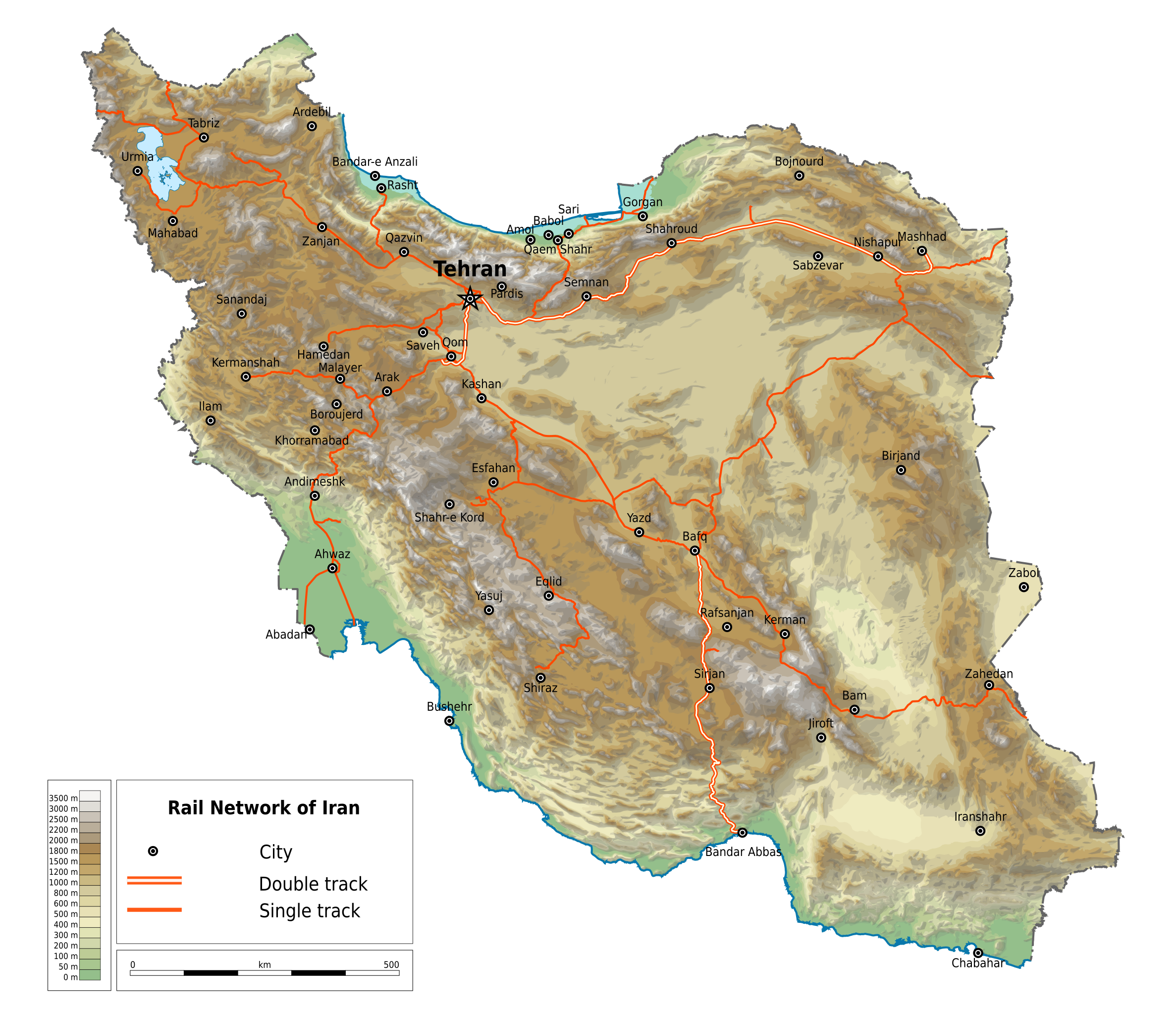
English: Map of railways in Iran (in English). Limits of the map:
|
| Dato | |
| Kjelde | File:Map Iran railways fa.svg |
| Opphavsperson | Ikonact |
| Løyve (Gjenbruk av denne fila) |
Any use of this map is subject of the license(s) stated below with the condition that you credit (Wikimedia Commons user: Ikonact) as the author . A message with a reply address would also be greatly appreciated. |
| Andre versjonar |
|

Lisensiering:
| This work contains information from OpenStreetMap, which is made available under the Open Database License (ODbL).
The ODbL does not require any particular license for maps produced from ODbL data. Prior to 1 August 2020, map tiles produced by the OpenStreetMap Foundation were licensed under the CC-BY-SA-2.0 license. Maps produced by other people may be subject to other licences. |
Eg, opphavsrettshaldaren til verket, publiserer det hermed under denne lisensen:
Denne fila er lisensiert under lisensen Creative Commons Namngjeving-DelPåSameVilkåra 4.0 internasjonal.
- Du står fritt til å:
- til å dela – til å kopiera, distibuera og overføra arbeidet
- til å blanda – til å endra verket
- På desse vilkåra:
- namngjeving – Du lyt godskriva verket på den måten som opphavpersonen eller lisensgjevaren har oppgjeve (men ikkje på ein slik måte at det kan verka som om dei går god for deg eller måten du nyttar verket på).
- del på same vilkåra – Om du remiksar, omarbeider, eller på annan måte byggjer på dette verket, kan du berre distribuera resultatet under den same eller ein samsvarande lisens som denne.
Filhistorikk
Klikk på dato/klokkeslett for å sjå fila slik ho var på det tidspunktet.
| Dato/klokkeslett | Miniatyrbilete | Oppløysing | Brukar | Kommentar | |
|---|---|---|---|---|---|
| gjeldande | 29. mars 2020 kl. 00:42 | | 2 318 × 2 000 (7,15 MB) | Ikonact | == {{int:filedesc}} == {{Information |description={{en|1=Map of railways in {{W|Iran}} (in English). Limits of the map:}} *N: 40.229° N *S: 24.327° N *W: 42.517° E *E: 64.314° E Equidistant Cylindrical projection; WGS 84 datum |date=2019-03-28 |source=File:Map Iran railways fa.svg |author={{U|Ikonact}} |permission=Any use of this map is subject of the license(s) stated below with the condition that you credit (Wikimedia Commons user: Ikonact) as the author . A [http://c... |
Filbruk
Det finst ikkje noka side som bruker denne fila.
Global filbruk
Desse andre wikiane nyttar fila:
- Bruk på de.wikipedia.org
- Bruk på en.wikipedia.org
- Bruk på fr.wikipedia.org
- Bruk på hu.wikipedia.org
- Bruk på it.wikipedia.org
- Bruk på it.wikivoyage.org
- Bruk på ja.wikipedia.org
- Bruk på nn.wikipedia.org
- Bruk på no.wikipedia.org
- Bruk på ru.wikipedia.org
- Bruk på tr.wikipedia.org
- Bruk på zh.wikipedia.org